HIKE with Purpose | 28 November 2026
Sat Nov 28, 07:30 - Sat Nov 28, 13:00
Helderberg Nature Reserve
ABOUT
Join Distance 4 Difference (D4D) for our next HIKE with Purpose on Saturday, 28 November 2026. We’ll explore Woodies Walk, starting at Helderberg Nature Reserve in Somerset West, with beautiful views over False Bay.
Your entry fee supports D4D’s work with vulnerable children in need. Experienced guides will lead the group, giving you the opportunity to learn along the way and enjoy the mountain in the company and safety of fellow hikers.
Places are limited to 30 participants.
Event Details:
- Dates: 28 November 2026
- Trail: Helderberg Nature Reserve - Woodies Walk
- Hiking Distance: 11km
- Elevation: 640m
- Fitness Level: Intermediate
- Guides: Each hike will be led by two experienced guides
- Cost: R242.50 + R7.50 booking fee. This include your entry fee (R30 per person) at the gate and a packet of our famous brownies. Our three guides are generously volunteering their time. All proceeds will benefit one or more of D4D's beneficiaries.
- Bulk discounts (for direct families only, eg Husband & Wife, Brother & Sister, Dad, Mom & Kids):
- 2 tickets = 5%
- 3 tickets = 10%
- 4 tickets = 15%
- 5 tickets and more = 20%
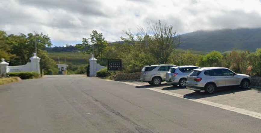
- Where do we start?: We would prefer if everybody stop outside the main vechile entrance gate at it is going to be difficult to manage the group if some is inside and some is outside. (Location pin: https://maps.app.goo.gl/vjGqpFbRmDGQDJC69)
What to bring:
Participants will need to bring their own food and drinks. Make sure you carry enough water. Bring a warm jacket - the weather can change suddenly. Check the weather updates in the days before the hikes. Remember a hat and sunscreen!
We will have some of D4D's famous HIKE with Purpose brownies to hand out!
About Distance For Difference:
Distance For Difference has been dedicated to making a difference in the lives of children in need since 2005 (22 years). Through the power of sport and community, we’ve raised and distributed over R14 million to various children’s charities across Somerset West, the Helderberg region, the greater Western Cape, and beyond.
Limited spots available - Book now!
Only 30 tickets will be sold. Join us in celebrating D4D's 22nd anniversary year with this unforgettable summer experience. Secure your spot today!
Looking forward to seeing you on the trails soon!
For further queries, please contact Lillibé de Jager @ 084 513 0591 or Caro Pieterse @ 079 875 1886.
Regards,
The HIKE with Purpose Crew
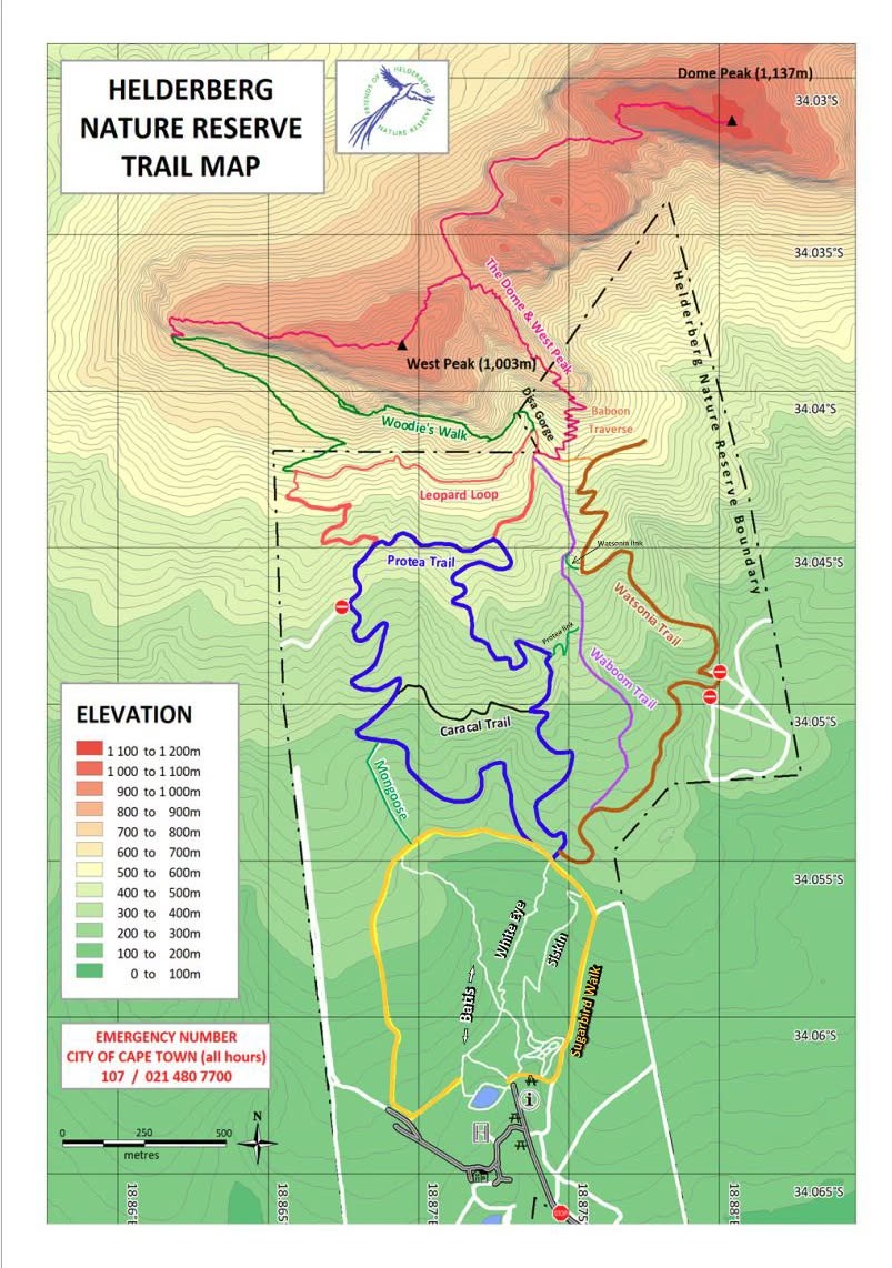
HELDERBERG NATURE RESERVE - WOODIES WALK (11 KM)
Summary
The Woodies Walk (see Map in seperate tab) in the Helderberg Nature Reserve is a scenic, non-peak high-altitude circuit.
- Duration: 5½–6½ hours
- Altitude: Reaches up to 814 metres high, contouring beneath Bute cliffs and the south face of West Peak.
- Route highlights: It connects via jeep tracks, the Protea route, and Waboom single tracks, passing through Disa Gorge's forested canopy and fynbos.
- Views: Offers expansive vistas overlooking False Bay and the surrounding area.
- Note: Part of the trail extends just outside the main reserve boundaries.
Description
Woodies Walk | Helderberg Nature Reserve
Woodies Walk is a scenic mountain circuit of approximately 11 km, starting in Helderberg Nature Reserve above Somerset West. The route climbs through fynbos onto the higher mountain slopes, offering wide views over False Bay and the surrounding Helderberg area.
Walked clockwise, the hike follows the jeep track uphill before joining a mountain path that climbs through a series of switchbacks. At “The Corner”, views open towards Cape Town before the trail turns east onto Woodies Walk itself. This undulating contour path runs beneath the cliffs of Helderberg West Peak, with views across False Bay towards Cape Point on a clear day. There are several places to pause, enjoy a snack and take photographs.
The return descends into Disa Gorge, where indigenous trees provide welcome shade after the open mountainside. From here, the route joins the Waboom Trail and winds through proteas and fynbos towards the lower reserve and parking area.
Allow approximately 5½–6½ hours, depending on the group’s pace and breaks. The route is graded moderate (2B), with a sustained climb, rocky sections and some exposure to heights. A reasonable level of hiking fitness and comfort on uneven mountain paths are needed. Bring sufficient drinking water, snacks, sun protection and a warm layer, as conditions can change quickly.
We will meet at the gate at 07h15: https://maps.app.goo.gl/vjGqpFbRmDGQDJC69
FAQS
1. Where does the hike start?
Helderberg Nature Reserve - Main Gate
Google Maps Location: https://maps.app.goo.gl/vjGqpFbRmDGQDJC69
2. What time do I need to be at the start?
07h15
3. What should I bring?
- Water: At least 2 liters
- Backpack
- Food: Energy snacks
- Hat
- Sunblock
- Windbreaker or rain jacket
4. What type of shoes are best for this particular hike?
- Lightweight hiking boots/shoes that have already been worn in to avoid blisters.
5. What should I wear?
- Lightweight hiking pants or shorts (long pants are recommended to prevent scratches).
- A breathable, moisture-wicking T-shirt.
- A fleece or light jacket.
- Wool or synthetic hiking socks to help prevent blisters.
6. I am not fit, can I still do the hike?
Yes! However, to make the experience more enjoyable, we recommend doing some light training beforehand.
Start walking regularly and gradually increase your distance and the difficulty of your walks.
7. What if the weather isn't suitable for hiking on the day of the hike?
Your safety and enjoyment are our top priorities. If the weather conditions are not favourable for hiking, we may postpone the hike to a later date. We'll closely monitor the weather forecast leading up to the event and notify you of any changes as soon as possible.
IMAGE GALLERY


ROUTE MAP